Walk About Zion – West Wall
THE WEST WALL
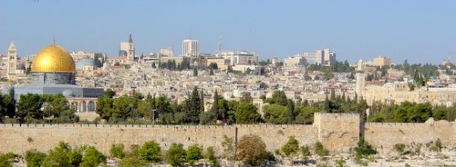
Now let us peek around the corner of the upcoming west wall toward Jaffa Gate. This is our last wall and is probably the most picturesque of them all. From this perspective we can see almost the whole of it. We can also see some of the beautiful and recent construction of the massive Mamilla renewal project.

As we begin this last leg of our journey let us once more mount the wall so that we may have a much better view of the surroundings. We want to also peek into the quarter of Old Jerusalem that we missed by our ground-level walk along the southern wall. So we will backtrack just a little.
Inside the southwestern corner we are looking at the Armenian Quarter. In the fourth century the Armenian nation was the first nation to turn to Christ. It seems that the Lord may have rewarded them by providing them a permanent place in his Holy City. The Armenians like the Jews suffered an awful holocaust brought about in their case by the Muslim Turks. This happened in the early 20th century and has been called the first genocide of that bloody century. About one and one half million Armenians were killed in this genocide. Many of those escaping came to live in the Old City.
The Armenians began to build religious structures in Jerusalem as early as the fifth century with the present Cathedral of St. James being constructed between 1142 and 1165, during the time of the Crusades. The cathedral, according to Armenian tradition is named after James the brother of Jesus. However it is also connected to James the brother of John, who was a disciple of Jesus. This disciple was beheaded by King Agrippa (Acts 12:2) and it is said that his head is buried in the church.
As we climb back on the wall we now look down on the inside at some of the buildings surrounding the St. James Church in the Armenian Quarter.

“Although you have been forsaken and hated, with no one traveling through, I will make you the everlasting pride and the joy of all generations” (Isaiah 60:16)
From the southwestern corner of the wall we can look outside to our left and see St. Andrew’s Scottish Church and Hospice. This building was erected in 1927 in memory of Scottish soldiers who died fighting for Jerusalem in the First World War. In ancient burial caves near this church some tiny silver plaques were discovered. They had apparently been rolled into scrolls in order to be worn around the neck. The plaques were written in ancient Hebrew with a text very similar to the Priestly Blessing of Numbers 6:24-26. They were dated all the way back to the 7th century BC.

St. Andrew’s Church
We would now like to take a quick look at the Hinnom Valley, Mount Zion, ourselves and our wall from across the valley. This will give us a little better perspective.

The Southern edge of Mt. Zion and the Hinnom Valley as it turns East

Mount Zion
In addition to the institutions we have mentioned on Mount Zion there is also the Greek Orthodox seminary (the rectangular building closer to the wall), and there is Gobat School founded in 1853 (front and right in the picture). It was the first building erected outside the city walls in the 19th century and was situated on parts of the ancient Herodian wall. Today the Gobat School is home for Jerusalem University College which was formerly known as The American Institute of Holy Land Studies. It was founded in 1957 by the evangelical teacher and pastor, Dr. Douglas Young, and opened at this location in 1967. In the Protestant cemetery adjoining this school many famous Christians of the past two centuries were buried.
We will now continue our journey on the wall and take a look from the west wall of the Old City where we are treated to a wonderful view of Jerusalem’s new city. Right in front of us and to the left we see the King Solomon Hotel. The taller building to the right is the Dan Panorama Hotel.


We are also treated to an excellent view of the first area to be settled outside the Old City. It was established by Moses Montefiore, an English philanthropist, beginning in 1855. Montefiore built two rows of apartments with a serrated roof style to match the Old City wall. Part of this structure can be seen at the bottom left of the picture above. The area was named Mishkenot Sha’ananim, based upon the Hebrew verse in Isaiah 32:18 which says:“My people will live in peaceful dwelling places, in secure homes, in undisturbed places of rest.”
In 1857 Montefiore also built the windmill we see in the foreground of the above picture in order that the residents might have some means of support. Unfortunately, although the Old City was crowded, its residents were at first fearful to live outside the city wall. In fact, even the city walls were locked every night to keep robbers out.
In 1892 the adjoining area of Yemen Moshe was established and by the end of the 19thcentury the area had some 600 residents. Today this area is filled with artist galleries and is one of the loveliest sites in Jerusalem.
Just below Yemen Moshe we see what is known as the Sultan’s Pool. This may be one and the same with the “Snake Pool” from Second Temple days. The pool in its present form was built by the Mamluk sultan in the 14th century. Since 1967 the pool area has served as an amphitheater for outdoor performances. It is important for us to realize that this depression is part of the Hinnom Valley. In the days of Israel’s kings many sacrifices to false gods were made in this valley. In Jeremiah 7:31-32, the prophet calls it the “Valley of Slaughter.” Because Israel had offered its children in the fire to other gods the day would come when the valley would be filled with slaughtered Israelites until there would be no more room.
 Sultan’s Pool
The Valley of Hinnom (Ge Hinnom) in Hebrew became a word to symbolize “Hell” in the New Testament. Also Judas Iscariot who betrayed Jesus was buried in the east end of
this valley.
this valley.

“Jerusalem will be a city without walls because of the great number of men and livestock in it” (Zechariah 2:4).
As we glance to the southwest from our lofty position we are provided with a spectacular view of the city’s large and fairly new suburb of Gilo. With its many recent additions Jerusalem will soon be approaching a million residents.
Oops! Occasionally in our elevated walk we not only get a bird’s-eye view but the birds seem to be viewing us. After all we are invading their sacred territory.

Here we would like to leave the fowls atop the wall and look at the southern portion of this west wall from ground level. It really provides us with a beautiful and memorable stroll. Also this area was excavated from 1973 to 1978, with many evidences of earlier walls being uncovered. The area has been made into another interesting archaeological park.


“Glorious things are said of you, O city of God” (Psalm 87:3).


“The LORD builds up Jerusalem; he gathers the exiles of Israel” (Psalm 147:2).
We now return to the top of our wall we enjoy a magnificent view of downtown Jerusalem. In the foreground we catch a view of the newly finished David’s Village. We note the ever present building cranes protruding from the city area. It has been said that the building crane has become the “national bird” of Israel.

Now we see that we are approaching the colossal Citadel with its towers. The built up area to our right is called the Kishla and was constructed in 1837. It first served the Turks as a barracks, police station and prison. Later it became a police station and jail used by the British. Many early Jewish underground fighters were imprisoned here. Today it is used by the Israeli police.
It is of note that much of this area inside the west wall was once the ancient and luxurious palace of Herod the Great. It continued to be the residence of rulers after him and then became the residence of Roman procurators while they were staying in Jerusalem. In all likelihood it was the real place where Jesus was tried before Pilate. It was Herod who built the three original and impressive towers of the Citadel area. Only one of these towers (named Phasael or possibly Hippicus) has survived to the present.
After the destruction of Jerusalem in AD 70 the Citadel was about the only structure that Titus allowed to stand. He left it to demonstrate to all how well the city was defended. This whole area then became the home of the 10th Roman Legion and they remained in the Jerusalem area for the next 200 years. Since there were not many battles to fight the soldiers spent much of their time producing clay bricks, tiles and milestones. Many of these were stamped with the seal of the 10th Legion.

From atop the ramparts we now get a closer view of the northern end of our wall and of the end of our journey. We can also see the very heavy traffic on Jerusalem Brigade Road just below us. This forms part of the main route from north to south in Israel and was undoubtedly the old road Abraham, Isaac, Jacob, David, and Jesus once traveled. It continues on south to join Bethlehem and Hebron Roads. To the north it goes on to Shechem (Nablus) and to other cities and countries.
In recent years it has been necessary to build a number of tunnels in Jerusalem to handle all the increased traffic. One of these tunnels can be seen at the top left of the picture. It conducts traffic under busy Jaffa Road and Tsahal Square to points north.

A close-up view of the tunnel

As we look left from where we are we can see the backside of the large King David Hotel. Through the years it has hosted the elite of the world. Today when kings, presidents and prime ministers arrive in Jerusalem this is usually their place of lodging.
“Nations will come to your light, and kings to the brightness of your dawn”(Isaiah 60:3).
“Because of your temple at Jerusalem kings will bring you gifts” (Psalm 68:29).
Sticking out over the top in this picture is the tower of the Jerusalem YMCA which was dedicated in 1933. This structure was erected by a partner of the same firm that built New York’s Empire State Building. We will get a clearer view of the building later. The “Yemka”as it is called by Israelis served in its early years almost as the first “country club” of Jerusalem. Israel’s soccer teams at one time played in the adjoining sports field and all types of Jerusalem social events were held there. In fact, the YMCA soccer field originally was the only one in Jerusalem. The same can be said about the swimming pool. By 2003 over 62 percent of the members of the Jerusalem YMCA were Jewish as compared to only 18 percent Christians.

We are now approaching the Citadel and we see what is called the Tower of David. This tower is not from David’s time but is in fact a 17th century Muslim minaret that got misnamed through the centuries. Nevertheless, it has become a famous landmark over the years as it has been reproduced as the “Tower of David” on numerous postcards, pictures and plates.

Just in front of us we get our last bird’s eye view of the approaching Citadel. We need to remember once again that most of the upper stones in this construction are from later times, particularly from the Ottoman Era. However, we can still find layers of original Herodian stones still in place on the surviving Tower of Phasael.

As we climb down from our wall we see a close-up portion of the vast $400 million Mamilla project with its many walkways and gardens. We can also see the shopping mall that runs all the way to the new city parallel to Yitskhak Kariv Street.
Much of this project is open to the public and it is now possible to walk from Jaffa Gate across the top of Hativat Yerushala’im (Jerusalem Brigade Road) to the right, which soon becomes Jaffa Road. Here along this new mall Jerusalemites can now lounge in open air coffee shops and cafes while they absorb the splendor of the Old City view.
We now are on the ground again and have an opportunity to enter the ancient defensive compound known as the Citadel. The first evidences of construction at this site date back to the First Temple Period which ended in 586 BC. Because King Herod later had a palace in this area he built three immense towers defending it. The base of one of these towers can still be seen with its carefully crafted stones bearing their characteristic Herodian borders. This remaining tower base is thought to be the remnants of the Phasael Tower, although some scholars think it belongs to the Hippicus Tower. The other two towers of Herod have yet to be discovered.
A few centuries after Herod, the Byzantines also fortified this area. After them came the Muslims, Crusaders, Mamluks, Ottomans and finally the British. Much of the structure we see actually dates from the Ottoman era. When the British took over Jerusalem near the end of World War I, it was at this site that General Allenby accepted the surrender from the Turkish military governor. Today this whole structure is included in the Tower of David Museum.
Let us enter the museum and observe the many layers of history and civilization represented in this unique place. First of all we would like to climb up to the top of its highest point, the Phasael Tower, and get of good orientation as to exactly where we are in the city. We want to begin this by taking a panoramic view starting at the south from where we have just come and swinging our camera left around to the north. This area is one of the higher points of the Old City and is about 2549 feet (777 meters) in elevation. When we consider the great height of the tower we are on we might say this is the highest and best viewpoint available in the city.
As we look south we glimpse two important Armenian institutions. First in the foreground we see the Armenian Theological Seminary which was completed in 1978.


Then we can make out the top of the very important St. James Church with its grey dome and cross (center).
As we swing around to our left foreground we see Christ Church. This Christian compound is located adjoining the Omar Ibn Khattab Square of the Jaffa Gate. Christ Church is the oldest Protestant church in the Middle East with construction on its building beginning in 1841. Today it provides shelter and support for several Christian church groups and ministries in addition to the Anglican congregation. Christ Church also operates a popular guest house, heritage center, Christian book store, plus various study programs.

Christ Church
“You will arise and have compassion on Zion, for it is time to show favor to her; the appointed time has come” (Psalm 102:13).
If we look directly over Christ Church we will see the newly constructed white dome marking what was called the Hurva Synagogue in the Jewish Quarter. Until lately it was just a ruin as we mentioned earlier, but now it is completely rebuilt.
As we look in front of us to the east we see the Temple Mount and its golden Dome. Of course we are once more looking at the Mount of Olives in the background. Then to the left we observe the impressive bell tower belonging to the Lutheran Church of the Redeemer. This church was consecrated in 1898 and built over the ruins of a Crusader church. As we view the Church of the Redeemer we are once more looking into the Christian Quarter from which we began our journey.

Now as we continue to the left with our panoramic view of the Old City we spy the huge twin domes atop the Church of the Holy Sepulcher.

The Church of the Holy Sepulcher
The Church of the Holy Sepulcher may indeed be the place of Jesus’ crucifixion and resurrection. Both of these supposed sites are included underneath its vast roof. The location was marked by Hadrian with a pagan shrine to either Venus or Jupiter shortly after the Bar Kochba Revolt of AD 132-135 ended. Of course it would have still been possible for the remaining local Christian populace to remember the exact site at this early time. After 325 Constantine’s mother, Helena, came to Jerusalem and quickly built a church at the location of the pagan shrine. Although the church has been destroyed several times by war, earthquake and fire, there has always been a structure of some kind located here. The present building dates largely from the Crusader period.
Now that we have done our panorama and found out where we are, let us take a look into the Citadel itself. This great fortress has had many levels of occupancy through the ages and literally encapsulates the city’s history. In the foreground we see Byzantine, and Crusader ruins. There are evidences of occupancy here from First Temple times to British times. After the war of AD 70 Roman soldiers were quartered in this section as we previously mentioned.

Byzantine and Crusader ruins in the Citadel
“On Mount Zion and in Jerusalem there will be deliverance” (Joel 2:32).
Before we make our exit from the Citadel let us say a word about the Jaffa Gate itself. It is still called by the Arabs Bab el-Khalil “the Gate of the Friend.’ It is called this since the gate not only services the route to Jaffa but to Hebron (City of Abraham) as well. It gets its name from the Arabic language relating to Abraham, since he was called “the Friend of God” (Isa. 41:8). While the Jaffa Gate itself still retains the “L” shaped defensive entryway it is of note that a large portion of the wall in this area was removed, with the moat being filled in, and the road paved for the arrival of the German Kaiser Wilhelm II in 1898. While the Kaiser rode into Jerusalem in all his pomp it is of note that General Allenby, when he took over Jerusalem in 1917, dismounted and humbly walked into the city through this same gate.
Let us take a peek inside the Jaffa gate where the wall was removed and where vehicles and pilgrims can now enter freely. We see that a lot of pilgrim traffic is taking place there on this warm sunny afternoon.

Let us also look just around the corner to the right of us at the size of the Phasael Tower with its glacis and moat below.


Now let us now step outside the gate and complete our journey around Old Jerusalem’s walls. We will walk first on the ground and then finish up our tour on top of the wall for a better view. We find ourselves standing beside the original Jaffa Gate (#8 on our map) looking northwest. This is a truly picturesque portion of the wall and no doubt the most popular section, attracting thousands of visitors and pilgrims every day. Let us turn around and take a look at the old Jaffa Gate itself.

The Jaffa Gate
So we will now stroll along our last section of the beautiful wall. We notice its palm and carob trees that provide cooling shade on blistering Jerusalem summer days.

“And the ransomed of the LORD will return. They will enter Zion with singing; everlasting joy will crown their heads. Gladness and joy will overtake them, and sorrow and sighing will flee away.” (Isaiah 35:10).

Jerusalem Pearl Hotel
As we near the end of this section we are greeted by the Jerusalem Pearl Hotel. It is the nearest west Jerusalem hotel to the Old City and obviously one with the best view.

Behold, we have arrived back to the place of our beginning! We are back at the northwestern corner of the Old City. Now in order that we can truly appreciate this popular part of the wall let us retrace our steps and climb on top of the wall at the Jaffa Gate. With that we will be able to finish our tour.
“Remember the LORD in a distant land, and think on Jerusalem” (Jeremiah 51:50).
Once more we will backtrack and mount the wall for the continuation of our final journey. We are now looking to the southwest at the traffic patterns around Jaffa Gate. Again we are seeing the area of Yemen Moshe with the King Solomon Hotel being the nearest.
“To you the nations will come from the ends of the earth…And this city will be inhabited forever” (Jeremiah 16:19 & 17:25).

After a short distance up our wall we come onto one of the very prominent institutions in the Christian Quarter. We are seeing the Latin Patriarchate, the headquarters of all Latin Christian work in the Holy Land.


Through the ramparts we get a parting view of the rectangular-looking King David Hotel and the YMCA tower in the distance, with the newly finished King David Village once more in the foreground.

As we come to the end of our walk we once more arrive over our beautiful park area where we began. We also see Tsahal Square (Israel Defense Forces Square) to the left of us. To our right we see the original Jerusalem Municipality building. We also see famous Jaffa Road as it makes its way to the sea. Just a few blocks up this road the New City of Jerusalem will begin.
Before we leave the Old City could we take just one parting glance at the beautiful west wall that we have just traversed?

Arise, shine, for your light has come, and the glory of the LORD rises upon you”(Isaiah 60:1)
Our journey is now complete. We have finished our walk around the biblical Old City of Jerusalem. May we never let it fade from our memory.

“If I forget you, O Jerusalem, may my right hand forget its skill. May my tongue cling to the roof of my mouth if I do not remember you, if I do not consider Jerusalem my highest joy” (Psalm 137:5-6).
A SIMPLIFIED JERUSALEM TIME LINE
Because of the many centuries involved and the numerous, bewildering layers of history and archaeology in Jerusalem, we want to list briefly the major events and historical periods encountered on our walk:
BC
2000 c. Father Abraham is called and later visits the Temple Mount area.
1200-586 First Temple Period. Jerusalem is conquered by David; Solomon’s Temple
is built and finally destroyed by the Babylonians.
is built and finally destroyed by the Babylonians.
536-AD 70 Second Temple Period. Temple is rebuilt and destroyed by the Romans.
37-4 King Herod rules and fills Jerusalem with magnificent buildings.
AD
4 BC-AD 33 Approximate time frame for the ministry of Jesus.
66-73 First Jewish-Roman War. Jerusalem is destroyed by the Romans and the
Jewish people are exiled once again.
Jewish people are exiled once again.
70-324 Roman Period
132-135 Second Jewish-Roman War (Bar Kokhba Revolt). As a result of this
war Jerusalem becomes a totally Roman city.
war Jerusalem becomes a totally Roman city.
324-637 The Byzantine Christian Period.
638-1099 The Early Muslim Period (Umayyad, Abbasid & Fatimid Dynasties).
1099-1187 The Christian Crusader Period in Jerusalem.
1187-1229 The Ayyubid Period. Saladin recaptures Jerusalem for the Muslims.
1250-1516 The Mamluk Period.
1516-1917 The Ottoman Period.
1917-1948 The British Mandate.
1948 Reestablishment of the State of Israel.
ABOUT THE AUTHORS
JON (YONI) GERRISH
Yoni lives in Jerusalem with his wife, Dalia, and their four young children. Although he is a citizen of the US, he has lived for 22 years in Israel. For the past 17 years he has worked as a licensed Israeli tour guide and also as a tour operator. Yoni presently serves as the Israel Director of the Christian organization, Jerusalem Cornerstone Foundation. In his work he not only organizes and brings many study tours to Israel, but his organization is able to distribute a great deal of benevolent help to the needy people of the land. He holds a Master of Theology degree in New Testament Studies from Jerusalem University College in Jerusalem. He has also taught courses in historical geography at this same institution.
JIM GERRISH
Jim is the father of Yoni and has lived in Israel for a total of 15 years, much of that time in Jerusalem. Previously he served several years as a pastor in the US and holds a Master of Divinity degree from Southern Seminary in Louisville, Kentucky (US). Jim felt Israel was so important that he moved his wife Betsy and their children to the land in 1982. Later he served in Jerusalem for a number of years as editor, writer and Project Director for the Christian organization, Bridges For Peace. Finally he founded and directed the Galilee Study Center at Migdal, near the Sea of Galilee. He has authored several books includingDoes God Play Favorites? (God’s Unique Relationship With Israel).
HELPFUL SOURCE MATERIALS
Ben-Dov, Meir. Carta’s Illustrated History of Jerusalem, Second Updated Edition. Jerusalem: Carta, 2006.
Meir Ben-Dov is author of several books and lecturer at Hebrew University. He is not only an archaeologist and historian but he has also served as field director for some of the most important excavations around Jerusalem.
Har-El, Menashe. Golden Jerusalem. Jerusalem/New York: Gefen Publishing House, 2004.
Menashe Har-El is a well known professor both at Hebrew University and Tel Aviv University. He has lectured at these institutions on the history and geography of Israel for almost half a century. Professor Har-El has been awarded many prizes in Israel for
his books.
his books.
Mazar, Eilat. The Complete Guide to the Temple Mount Excavations.Jerusalem: Shoham Academic Research and Publication, Old City Press, 2002.
Eilat Mazar is the granddaughter of Professor Benjamin Mazar, who headed up the excavations around Jerusalem’s Temple Mount from 1968-1978. She continues to head up the extensive project of publishing Professor Mazar’s findings. Eilat Mazar was also part of the excavation team at the City of David and later led the excavations at Ophel. Her book is a gold mine of information concerning one of the most important areas of the
whole earth.
whole earth.
Murphy-O’Connor, Jerome, OP. The Holy Land, An Oxford Archaeological Guide from Earliest Times to 1700, Third Edition. Oxford/New York: Oxford University Press, 1992.
Although this archaeological guide covers the whole of Israel the section on Jerusalem is very thorough and particularly helpful.
Wager, Eliyahu. Illustrated Guide to Jerusalem. Jerusalem: The Jerusalem Publishing House, Ltd., 1988.
Eliyahu Wager’s guide is the one indispensable book for a walk around Jerusalem or even for a deep study of the city. It is compact, extremely well organized, and crammed with needed facts and information.
Saturday, October 20, 2007
Jerusalem, Old and New-ish
Last week I was finally able to take my parents to the Kotel HaMa'aravi. My mother had been saying that she wanted to go since they first arrived.
When I was walking to their hotel, I glanced at the "Pearl" hotel and the reflection in the window reminded me of the Old City Walls.
 Here's a photo from their hotel room.
 Finally, the Old City. We took a taxi from their hotel, but there still was a lot of walking.
 Here they are after going to the Wall itself. It was Thursday, so there were lots of Bar Mitzvah Celebrations. Lots and lots of people were there.
 My parents had been to the PNAI Convention, as you can see on his water holder.
No comments:
Post a Comment